
NS in Eastern Appalachia
Frisco, TN - Knoxville, TN

Introduction
This is a part of the overall Frograil Norfolk Southern Railway Appalachian Route Tour. As of June 2006, the tour has been completed between St Paul, Virginia, and Knoxville, Tennessee, a distance of about 167 miles. Stay tuned, as we'll hopefully be adding more soon. This segment of the tour currently extends about 84.8 miles, and is complete between Frisco and the eastern approach to John Sevier Yard in Knoxville.
The tour is rural and somewhat rugged between Frisco and Bulls Gap, and there is plenty of railroading action, so take your time and enjoy yourself in the high plateau of northeastern Tennessee. West of Bulls Gap, the ruggedness and size of the hills gradually diminishes, but you are never out of the hills in eastern Tennessee.
Contents And Navigation:
Contributors
Tony Hill: Webmaster and all text, unless otherwise noted. Any use of the first person singular pronoun in this tour refers to Tony.
Brian Rackley: Mile point listing and other supplemental information and general assistance.
Train Gif Artists. Train gifs add life and color to this page, and take almost no time to load. I stick these gifs in whenever I get the urge -- there is no rhyme or reason, I just like them. You can see hundreds and hundreds of train gifs by clicking on the Train Gifs navigation button at the top of each Frograil page.
Help
If you'd like to contribute to this or any other Frograil tour, simply e-mail me here, and let me know what you're interested in. We'll work together -- you supply the data, and I'll take care of the HTML stuff. Frograil can only be as good as its contributions, so keep 'em coming. Over 1,300 folks a day visit Frograil, so your material will not just be moldering away -- it will be used by railfans.
Supplemental And Back-Up Data
The Railroad -- Geography. Frisco is south of the Clinch Mountain monolith, and the trip further south is not really mountainous, but it's darned hilly, and features curvy topography. Even though the basic roadway has been in existence since well back into the 19th Century, it has been continuously upgraded and improved. The Southern Railway always maintained its physical plant in excellent order, and Norfolk Southern has continued that tradition. The end result is that the trains seem to effortlessly glide thru their environment. The tour between Frisco and Bulls Gap is typical Tennessee plateau, with mountains always visible in the distance, and lush green grass, farms, and cows all along the way. It's a beautiful part of our country.
West of Bulls Gap, the tracks are still beautifully maintained, but the hills are somewhat smaller, and the lay of the land is a little gentler. That makes for faster, quieter trains.
The Railroad --Traffic. There is a manifest train between Frisco and Knoxville daily, but the vast majority of the traffic is coal going south and empties going north. In very hot or cold weather, the traffic is quite a bit heavier than in mild weather. Expect to see 6-10 trains per day south of Frisco to Bulls Gap. At the latter, some of the traffic from Frisco goes down to Asheville via Douglas. This traffic is more than made up by traffic to/from Bristol, however. South of New Line, traffic to/from Asheville joins the line, which makes the New Line - Knoxville section the busiest on the entire Appalachian tour, so far.
Don't expect to see ore trains, very many grain trains or (certainly not!) intermodal trains. This is first and foremost a coal hauling road, and there is significant manifest thrown in to make it interesting.
Photographic Considerations: As I've done in several Other Tours, I've attempted to rate the photo fields for all 4 quadrants of many crossings detailed in the tour. The following format is used: NE2, SE1, SW4, NW4, where you go clockwise around the quadrants from northeast to northwest, and numerical ratings, from 1 to 4, with a 1 being excellent, and a 4 being non-existent, are assigned. Note that I'm rating only photo field availability, not the photogenic qualities of the site. I'm a picture taker, not a photographer, and you guys who are good photographers will have to make your own determinations.
Life Support. Even though this is mostly a very rural tour, much of it is close to US-11E, US-11W or US-23. Rogersville, Kingsport, and Morristown are close by, and offer everything up to and including hospitalization. While I usually emphasize life support opportunities (gas, food, lodging, etc) in rural tours, this one really never gets far from basic amenities.
Abbreviations. Some phrases are used repeatedly in this tour, so I've developed some standard Frograil abbreviations:
AG. An at-grade crossing.
NAG. A not-at-grade crossing. Unless I mention otherwise, these are usually not worth the time and trouble to drive to.
NARL. Not a railfan location. This is because of any number of reasons, such as lousy photo ops, dangerous, no shoulder on a NAG bridge, etc. As a general rule of thumb, it is wise to avoid NARL's.
NFOG. Not found on the ground. Often, very minor roads depicted on maps of rural areas do not exist on the ground, turn out to be private driveways, or have become overgrown in forests. I lump these together in the NFOG category.
Mapwork: Much of the tour is not easy if you have no detailed map for back country roads. I definitely recommend you get a DeLorme Atlas & Gazetteer, study it before your trip, and copy pertinent pages for your field work. You can find information here about Railfan Maps that are available.
WEBMASTER'S NOTE: I do not recommend, or even condone, walking along the tracks, as this means trespassing or exposing yourself to danger. You will have to be creative, in some instances, to avoid trespassing while getting to the detailed locations included herein, but you will either have to be creative or not visit those sites. At no point in this tour guide, or any other tour which is part of Frograil, is it recommended that you trespass or expose yourself to danger. If you are a fool and have a leg cut off (or worse), don't come crying to me: You have been warned. Trains are big, powerful, and often surprisingly quiet. Don't end up being a statistic.


Railfan sites:
The Tour -- Frisco - Knoxville, TN
Frisco -- Yard. If you are just starting the tour here, we'll start you in a logical place, one virtually at the Tennessee and Virginia border. From I-181 in Kingsport, go north to the last exit, where you must either go to the right onto TN-36, or left onto US-23. Take the right, and just a short while later, a left onto TN-346/Carters Valley Road. This may look like a minor road, but in terms of traffic, it's the major east/west road in this area. After 3 miles or so, look for Waycross Road veering off to the right. If you're observant, you'll see a bent "Frisco Yard" green sign with white letters at the intersection.
Take Waycross Road, and then take a right onto Underpass Road, and just before the tracks, take another right to go up the very steep drive to the yard.
If you are continuing this tour from the north, and are coming from the north end of Frisco Yard, continue west on VA-614, which will shortly T at VA-804. Take the left, and you'll almost immediately be in Tennessee. In the latter, this road is Underpass Road. Immediately beyond the NS underpass, there is a road going up into Frisco Yard. Before you get to this underpass, you'll see a fairly large, yellowish building standing above the yard. This is the well-known Frisco Yard office. The turn from Underpass Road up to the yard is impossible from the north, so continue on, turn around somewhere, and come back, take the right, and go up into the yard parking area.
This location is on private NS property, so I'm going to give you some necessary advice: This is a most interesting place to visit, and I do advise driving up and looking at the unique yard office. If you shoot railroad structures, this is a must have, indeed. Take your photo from the car, and then leave. If there is a train pointing toward you, you can also shoot the lead engine from your car, but do not drive down into the yard area. Turn around and leave. If, when you enter the yard office area, there are railroaders present and working, don't even take pix from your car. Just turn around and leave.
The yard is the northernmost point at which you will see manifest freight trains. Everything going north or coming south from this point is coal only. The reason the yard is here is not because of coal, but the large amount of manifest freight exchanged with CSX (ex-Clinchfield Railroad), and gathered by NS at the immense Eastman Chemical complex in Kingsport.
Back to the Site Listing Back to the top
Frisco -- Waycross Road. Go back out to Underpass Road, turn left, and go out to Waycross Road. Turn right, cross the tracks on an at grade crossing, then go under another set of tracks, and park to the left. The first set of tracks is a connector between CSX and NS, while the upper line is the NS main heading south from Frisco Yard. Because of private property concerns, you'll have to take all pix from the street, but that's usually not a problem. Between the two sets of tracks, there is an excellent shot to the south of the main line, and a good shot to the north. If you're lucky enough to get a train on the transfer track, you'll have no problem getting a good shot.
Back to the Site Listing Back to the top
Frisco -- Choo-Choo Mobile Home Park. Go back out Waycross Road to Carters Valley Road, take a right, and go over the connecting track. Take the next right into the Choo-Choo Mobile Home Park. Go to the end of the paved street until you can go no further, and park to the left. The main line is right in front of you, but there is heavy brush, and pix are a no go here. This location is included because you can see the "Frisco" electronic tower to the northeast, and the point at which the connector from CSX joins the NS main at the Frisco Yard throat. It's an interesting railroad point. This is MP 46.3TC.
Back to the Site Listing Back to the top
Frisco -- Grand Overlook. Continue west on Carters Valley Road and turn left onto Grandview Drive. This will bend 90° to the right and T at Randview Drive (watch the spelling carefully, as it's confusing). Before getting to Randview, find a place to park. Walk to Randview, take a left and go maybe 30 feet and look to the northeast. There is a superb late afternoon shot of the train departing Frisco thru the trees and countryside. It's very pretty, and is certainly a cold weather shot.
You can walk down to the tracks on Randview, but the road was cut many years ago, and there are no photo ops close to the tracks.
Back to the Site Listing Back to the top
Frisco -- McCracken Lane. Continue west on Carters Valley Road, and as you leave the Frisco area, look for McCracken Lane on your left. Take it to the tracks and park. This is another location where you'll have to shoot from the road. Here are the ratings: NE3, SE3, SW3, NW2. While these are fairly poor ratings, what makes this location interesting is the cut on both sides of the tracks to the northeast. I think a good photographer, with some planning and luck, could get an excellent action shot here.
Back to the Site Listing Back to the top
Marshall. Rather than going cross country, go back up to Carters Valley Road, take a left, and go a couple of miles to Independence Avenue. Take a left and drive to the community of Marshall. Stay on Independence, pass Ellis Road to the right, and park in the vicinity of the tracks. The is the north end of a passing siding, and there is an electronic tower ("Click") with a big radio antenna just to the south. Photo fields are NE2, SE1, SW2, NW2. The southwest quad is enhanced by going up the small rise and shooting "around" Click. This is probably the best photo location we've seen since leaving Frisco, but note that the tracks are dead north/south, so northbounds will virtually always be out of the sun.
Back to the Site Listing Back to the top
Mount Carmel/Green Village. From Marshall, go back the way you came, but turn left onto Ellis Lane, just west of the tracks. This will take you a few miles to the west, and will then veer south and become Hammond Avenue. This will take you several miles to the town of Mount Carmel. You'll go under the tracks and will arrive at US-11W. The underpass is NARL. In Mount Carmel itself, you can take a right from the highway to go north on Edgewood Avenue, but I did not observe whether the crossing was at grade or not. From Edgewood onward, Main Street/Main Boulevard forms a sort of frontage road thru Mount Carmel, Block City and Green Village -- all of which seem to run together.
Continuing southwest on Main, you'll go under a large railroad bridge which is taking a spur into the Holston Army Ammunition Plant. We will interrupt the tour to explain the nature of this "spur", using information provided by David DeVault andThe Center for Land Use Interpretation. From the latter comes the following basic information about the plant:
"This government owned, contractor operated ammunition and explosives plant is the largest capacity supplier of high performance explosives in the country. Among the many unique products produced here are the explosive powders used to trigger nuclear weapons. The 6,000-acre installation has 141 munitions storage magazines, around 900 employees, and was operated by the Holston Chemical Company, a subsidiary of the Eastman Chemical Company (which was spun off of Kodak in 1994), from the 1940's to the late 1990's (Eastman operates one of the largest chemical plants in the country in nearby Kingsport). In 1999, Royal Ordnance, a division of English defense giant BAE, took over operations. Holston AAP has two locations, Plant A and Plant B, separated by 4 miles, but connected by a rail line. It is the only site in the US for the production of certain types of explosives, including HMX and RDX."
David tells us that the railroad between the NS line that we're following, and the CSX ex-Clinchfield Railroad to the east in Kingsport, is a US Government railroad, operated currently by Rail Link, although you may see lettering different than that on their two rebuilt geeps. The railroad was known as the Interplant Railroad. This name is found on DeLorme, but not on Steam Powered Video or MapQuest. David also mentions that the railroad is fenced and there is a large pipeline paralleling the tracks. Also, both CSX and NS have access to the line, so you might be surprised by something you'd not ordinarily expect. The railcar business in and out of the Eastman complex in the southwest portion of Kingsport is massive, and the Interplant Railroad is the only way NS can directly access the plant. We now resume the tour.
Just beyond this point is Dover Avenue. Take a right, go under (?) the tracks and take an immediate left onto Beech Street. This runs parallel to the tracks for some 10 large blocks or so. There are many excellent photo locations between Beech and the tracks, but there is a serious drop off on the other side of the tracks. The line runs pretty much dead northeast/southwest here, so photos are good much of the day.
When you get into Green Village, the road will leave the tracks minimally, and just before that happens, you'll note the MP 52 marker.
Back to the Site Listing Back to the top
Church Hill -- Silver Lake Road. Somewhere along the way, the name changes from Beech to Old Stage Road. At Carolyn Avenue, take a left and then a right to re-join East Main Boulevard. As you approach Silver Lake Road, park on the right in the large open area. Photo fields are: NE4, SE1, SW4, NW4. Pretty lousy location, but the view from the southeast quad makes it well worth a stop. A weed whacker would be helpful here.
Back to the Site Listing Back to the top
Church Hill -- Maple Avenue. Continue on into Church Hill, pass up Hawkins Avenue and Old Stage Road, as these are NARL, and park in the area of the crossing of Maple Avenue. There is a large municipal parking lot there that has been created just for us railfans, no doubt. The municipal lot is to the southwest of the crossing, and there is also a large church parking area to the southwest, and it is elevated somewhat above the tracks. Here are the photo ops: NE4, SE1, SW1, NW1 -- pretty gaudy numbers! This is an excellent area for photos, whether you go for big blobs or railroad action photos.
Back to the Site Listing Back to the top
Church Hill -- Central Avenue. One of the difficulties of writing a tour such as this is that it is quite difficult to give you an idea of the topography of the area we're touring. Thru Church Hill, the line curves a good deal, and there are places with large embankments, and others that are street level. As we leave Maple Avenue via Main Boulevard, there is a somewhat significant valley, and when you get to Central Avenue, the railroad is on a high fill. Take a right onto Central Avenue and drive towards the fill, but park well south of it. You have an excellent photo up the embankment to the west, and it would be great for morning northbounds. There is no photo to the east.
Back to the Site Listing Back to the top
Church Hill -- Mill. As you depart Church Hill, you leave West Main Boulevard via Goshen Valley Road, but the crossing on US-11W and Goshen Valley roads are NAG/NARL. Continue west on US-11W, to a left on New Canton Road. This will T at Holliston Mills Road, where you should take a right to continue west. You can go to the left at Holliston Mills Road, but the tracks are hopelessly treed in, and there are no railfan locations in this direction. To the west is a large wide spot in the road that is used by trucks waiting to enter and/or leave the area of the mill. Park there, and walk across the road.
Mile marker 57 is here, as is an intermediate signal. The tracks are northeast/southwest, and the photo fields northwest of the tracks (where you are) are outstanding. Do NOT cross the tracks, as that is mill property, and you are asking for trouble when you trespass on their property.
Back to the Site Listing Back to the top
Stony Point. Leaving the Church Hill area, you pass Robin Hood Lane and Greenland Park Road off US-11W, but ignore them and just keep on heading southwest. As you approach the Greenland community, you can check out Greenland Road and Afg Road, but these are NAG/NARL's, so just keep heading southwest. West of the latter, look for Kingsport Highway, which sloughs off of US-11W, and then parallels it to the south. I'd recommend you follow this road, as the US highway tends to be too fast for any fanning decisions.
You'll pass Ferry Road, which leads to the tracks on an AG/NARL, private road crossing, and then come to the community of Stony Point. Note that this is variously spelled as Stony or Stoney. There is a blinker at Stony Point Road/Phipps Bend Road (same road -- name depends on where you are), and you should turn left to go down to the vicinity of the railroad. There is a creek here, and that creek and the street go under a nice trestle. The tracks are fairly treed in, and would be tough for photos, but the area is fairly large, so winter photos could be taken. You'll not get roster shots up close, but good railroad photos are possible. Between this point and Surgoinsville is the "Surgoinsville" defect detector at MP 61.1.
Back to the Site Listing Back to the top
Surgoinsville -- Riverfront Park. As you approach Surgoinsville, MapQuest shows River Road going off to the south with a crossing, but I did not see that road. Further on, Millers Bluff Road goes to the left. Take Millers Bluff, go under the tracks, take an almost immediate right turn, and then park in either of the parking lots in front of you. This is a lovely park which features beautiful viewing of the Holston River, which is one of the prettiest rivers you'll see anywhere. There is a short, paved walking trail, a boat put in, and lots of room for the kids and Fido to run around. Alas, the viewing of the trains is poor, as the tracks are treed in, but this is a nice place to relax and picnic.
The next location is literally right across the tracks, but you'll have to drive to it, as the embankment is too steep to walk up.
Back to the Site Listing Back to the top
Surgoinsville -- Depot Street. Go back up Millers Bluff, turn left and go back under the tracks, and at Kingsport Highway, take a left and bear left after that onto East Main Street. The first left is Depot Street; take it and drive carefully down to the tracks. There is an open area where the station used to be, which gives plenty of room for photos. The tracks are fairly north-south here, so photos are quite possible much of the day. I'd rate the photo fields W1, E4, as the east side drops down the cliff of the embankment. There is a photogenic signal bridge immediately north, at the north end of the Surgoinsville siding. This is a pretty nice little location, but stay back from the tracks to avoid trespassing. This is MP63.4.
Back to the Site Listing Back to the top
Miller Flats. Depart Surgoinsville via Main Street, and it will continue for several miles to the southwest. Before getting to the entrance to the Hawkins County airport, take a left onto Williams Road (it may be signed as Miller Lane, as Miller Road actually comes out of Surgoinsville, and is a hellacious road cross country). Take Williams south to a NARL crossing, and the road will turn 90° right, and parallel the tracks to another crossing. This latter is known as Miller Flats, and is a good place to watch trains.
To the southwest, the tracks come up on the south side of the river, cross it, and then go along the flat flood plain to this location. Photo ratings are NE2, SE1, SW2, NW3. The MP 66 marker is just north of the crossing. There's a nice curve towards the south just beyond the crossing. This is a lawn chair and cooler location. It's a good place to meet friends and tell railfan lies.
Back to the Site Listing Back to the top
Miller Flats -- Panorama. Cross the tracks and continue along Williams Lane (the name may have changed at the NARL crossing to the northeast). You'll note that you're in a flood plain, and as you go away from the tracks, maybe a quarter mile or so, you'll also note a lovely panoramic view of the railroad trestle coming across the river, and then the embankment towards the previous location. The railroad has become virtually north/south at the trestle, so lighting is not going to be easy for you, but with the proper late afternoon lighting, I think a good photographer with good equipment could get the Great American Train Photograph here.
Back to the Site Listing Back to the top
Honeycutt. The next location is close, as the crow flies, but will require a major detour and some nasty back road driving to get to it. Therefore, I consider it every bit a combat railfan location. I also consider it to be well worth the trouble getting to it.
Go all the way back up Williams Lane to Main Street and turn left. You'll shortly see Main Street swing north as TN-346, which will rejoin US-11W. The easiest way to get to Burem and Honeycutt is to take that right, go to the highway, and go all of the way into Rogersville, and then come back out -- southeast -- on TN-347/Burem Pike. However, if you go straight where TN-346 goes north from Main Street, you'll have a much shorter drive, and most of the road isn't all that bad. Somewhere, probably at the TN-346 turn, Main Street out of Surgoinsville becomes Old Stage Road, and that road will take you in an almost straight shot down to the Burem Pike just north of the Holston River. Obviously, as you twist and turn thru the countryside, you'll have a hard time believing you're going in a relentlessly southwest direction, but far more than most secondary roads in this part of the country, you are going in an almost straight line.
The reason we have to go thru all of the above efforts is because once south of the Holston, there is no way for us to get trackside without crossing the river ourselves. How to do that is the problem, as between Surgoinsville and Burem, there are no river crossings. Whether you're coming via Burem Pike out of Rogersville, or cross country via Old Stage Road (which joins Burem Pike just north of the river), cross the river heading southeast, cross the tracks (we'll come back to this location), and take the first left (which is easy to miss), onto Opossum Hollow Road. This one is very narrow and curvaceous, so slow down and take it easy. You'll eventually get to a crossroads, and there will be a nice country church. This is Honeycutt Road. Take a left and drive up to the community of Honeycutt.
Parking is a little tight but possible. You will have to take any photos from the road, as there is private property right up to both road and tracks. However, you can get some very good shots here: NE2, SE1, SW1, NW3.
You are in a very rural and private community at the end of the road, so to speak. Be very, very careful not to trespass or impede traffic in the area. Be friendly and say "hi", and don't spend a whole lot of time in the area.
Back to the Site Listing Back to the top
Burem. Retrace your drive down Honeycutt Road, take a right onto Opossum Hollow Road, and go back out to Burem Pike. Take a right to get back to the crossing and park. This is not really what I consider a railfan location, but I've included it because this is the first place to get trackside after leaving Honeycutt. If you need to get trackside fast, this is the only place to do it.
Back to the Site Listing Back to the top
Burem -- Tunnel Hill Road. This is a much better location than Burem. Continue back to the west, and take your first left onto Tunnel Hill Road. There is a church with parking behind it. The railroad is slightly southeast - northwest here, and there are 2 tracks at the crossing, because this is the middle of a very short, but obviously well-used siding. This is a very odd piece of railroad, as the "detector" appears only to be for the siding track, and there are inward facing signals on either side of the detector. Apparently, trains routinely are routed thru the detector, which looks like a dragging equipment type. Perhaps the purpose is to check for open hopper doors, but that's just a guess. Enlightenment would be welcomed.
[Webmaster's Note: As of June 2006, Mark Landgraf has cleared up the mystery of what this odd siding is for. There is an in-motion scale and a car identification reader. Together, they identify and weigh each car rolling over the siding's scale.
There is good viewing here, and it's a good place to relax.
Back to the Site Listing Back to the top
McCloud -- TVA Pond. To get to the next location, it's necessary to go around in a big circle, so continue down Tunnel Hill Road. You'll cross the tracks AG, but it's NARL. Just keep going all the way to Webster Valley Road and take a right. When you come to Old Highway 70S, take a right on TVA Pond Road. Note that MapQuest shows this road as Old McClound Road. This is the McCloud area. The reason we have had to make this large rectangular route is because between the crossing just mentioned and McCloud is the John Sevier Steam Plant, a coal-fired power plant, and the destination for a lot of the coal that we've seen on the tour down from the north. It's worthwhile to note that, as we get closer and closer to the Knoxville area, you'll see Mr. Sevier's name everywhere. There is a Sevier County, a city of Sevier, etc, etc. You are encouraged to read his biography, as he was a man who accomplished as much as any early American. He was the father of the State of Tennessee -- and that is only one of his many accomplishments.
TVA Pond Road will take you back to a good sized pond that separates the road and the main line. You can see a little switching action behind the main, but there is a lot of stuff in the way. There is some clutter at the edge of the road and tracks, but there are enough open areas to make the location worthwhile. In fact, this is a pretty good photo spot, if you're patient and the light is right. Do NOT attempt to get close to the tracks.
Back to the Site Listing Back to the top
McCloud. Go back to Old Highway 70S, take a right, and just before going over Dodson Creek, take a right onto TVA Road. This is the main entrance into the power plant complex. Before you get to the non-public part of the road, however, there is a decent crossing: NE1, SE4, SW4, NW1. There is a set of intermediate signals and an electronic tower "McCloud", at MP 75.5. Viewing from the north is excellent, but there is nothing from the south.
The Dodson Creek trestle is some 300 yards to the southwest. For the sake of future railfans, I hope someone local to the area would cut the one shrub to the southwest that interferes with the view when the leaves are out.
Back to the Site Listing Back to the top
Coran -- Old Highway 70. Go back down TVA Road and take a right to continue west on Old Highway 70. You'll cross Dodson Creek, and then go northwesterly to a sort of lazy S crossing. Photo ratings are NE4, SE4, SW1, NW1. Since the western quads are so good, and since the tracks are virtually east/west, you can get pretty good shots here most of the day. To get good shots from the southwest, go up the driveway a little ways.
Back to the Site Listing Back to the top
Coran. The railroad and road will become separated for several miles, so just head west on Old Highway 70 until it T's with TN-66, a major state highway. Take a left and go all the way to TN-70, which was certainly relocated far from the original Old Highway 70. Take the left onto TN-70, and go over the tracks on a NAG/NARL, and immediately look for Coran Road to the left. It comes on you fast, and is a very small road. As you get about 1/3 to 1/2 mile north of TN-70, you'll come to a farmstead with lots of equipment strewn around. To the west is a large field that someone apparently expects to turn into a development of some sort. There is a crude crossing into the field. NE4, SE2, SW1, NW1. There are intermediate signals here.
Back to the Site Listing Back to the top
Otes -- Old Highway 66. Go back south and cross TN-70. There will shortly be a crossing off to the right, but it is NAG/NARL. Bear to the right when you get to Old Highway 66. As you go southeast on the latter, you'll be in a valley formed by Honeycutt Creek. There is a lovely, pastoral view as you begin to approach the tracks and creek, so be on the lookout for a nice train scene. Parking is a problem, so you might want to drive it once to get the location you want to shoot from, and then park and walk back.
Continue south on Old Highway 66 until you can turn left at Fork Branch Road. This area is known as Persia. The underpass in not only NAG/NARL, it is really, really low. I got out as my wife drove our high top van thru. She only proceeded after I checked the vertical height. We made it with about 4" to spare. Keep on Fork Branch Road for several miles, until a T at TN-66. Take a left and drive all the way to where Old Highway 66 comes into TN-66. (Webmaster's Note: There is a crossing via North Fork Branch Road that I completely missed while doing map research for this tour, so I did not observe it. The tourist will want to check it out.) The old road has looped far to the east of where we left it at Persia. The crossing on Old Highway 66 is NAG, but it definitely is a railfan location. Do not attempt to drive anything but a very small vehicle thru the underpass. We didn't even make the turn from TN-66. You can easily walk from TN-66 to the underpass on Old Highway 66. The view from the west is wide open, and the east probably is, too.
Note that somewhere in this area is the Otes defect detector.
Back to the Site Listing Back to the top
Otes -- Speedwell Church Road. A little further south via TN-66 will take you to Speedwell Church Road. Take a left and find a place to park. Photo ratings are: NE1, SE3, SW3, NW1. Bear in mind that the tracks are northeast/southwest here, so the photo ratings are more of an X than a cross. Also, there are houses and private property on all 4 quads, so you'll have to shoot from the road. Be alert. Finally, there is clutter on the southwest that you'll want to "work around" with your photos.
Back to the Site Listing Back to the top
Summit. Get back on TN-66 and continue south. You'll pass Summit Hill Road on the left, and it leads to an area with a pretty view of the tracks, but there are no shoulders, and parking is a problem. Also, the crossing itself is NAG/NARL. Therefore, continue south on TN-66 to a left onto Beech Grove Road (Lawson on both MapQuest and DeLorme). This is an excellent photo location. There are 2 tracks, so somewhere north of here and out of sight is the beginning of double track southward.
Photo ratings are NE1, SE1, SW1, NW3. Very nice.
Back to the Site Listing Back to the top
White Horn. Further south on TN-66 is the community of White Horn. Take a left onto Guthries Gap Road. The tracks at the crossing are northeast/southwest, and are more steeply north than what we've seen for quite a few miles. Photo ratings at the crossing are NE4, SE2, SW1, NW1. However, if you walk about 100 feet east of the crossing, you can shoot between a couple of old farm buildings, and across a farm field to the northwest, and get excellent pictures. The old house here is inhabited, so be mindful of private property.
Long hopper trains up from Bulls Gap will sit south of the road, waiting clearance to go north into single track territory. Apparently, if they wait north near the end of double track, they will foul Beech Grove Road, and might even foul Guthries Gap. They are very long trains. This is MP 84.0.
Back to the Site Listing Back to the top
Bulls Gap -- Oak Street. We are now coming into the Bulls Gap area, and this tour is about to get very different. TN-66 goes straight into the town, and there is a crossing at Shephard Drive, but it is in an industrial area, and is NARL. Continue on into town and take a left onto Magnolia Avenue. At the foot of Magnolia, take a right onto Oak Street and park.
Bulls Gap is confusing, mainly because you cannot see the overall layout from any one vantage point. Also, what should be northeast - southwest trackage actually goes thru the town southeast - northwest! So, here's what happens. Trains can go to three basic destinations from Frisco: Asheville, Bristol, and Knoxville. The following very crude drawing illustrates what gives in Bulls Gap:
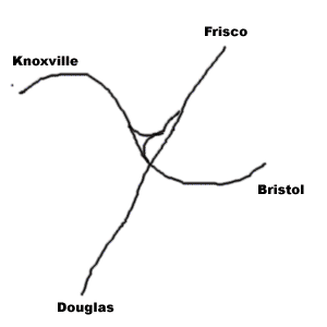
Just north of the Oak Street location, the track we've followed south from Frisco has met the track coming up from Douglas; trains on the latter are to/from Asheville, North Carolina. Therefore, from here on in this tour, we have lost the Frisco/Asheville traffic. The three tracks you are looking at, nearest to farthest, are the lead to Knoxville (the line we will continue to follow), a connector track, and the line up from Douglas. Photos to the northeast are pretty decent, but there is nothing from the east, as you have to walk across several tracks to get there.
We will now proceed further thru Bulls Gap to continue towards Knoxville.
Back to the Site Listing Back to the top
Bulls Gap -- Couch Street. Continue south on Oak Street, and take a right onto Quillen Avenue. Turn left on Main Street/TN-66, and just before US-11E, take a left onto Couch Street, and drive to the end. It is an interesting area! Walk to the south, underneath the US-11E overpass. Looking due south, you can see the point at which the line we will follow to Knoxville diverges to your right, and the line to the south leg of the wye goes directly south. It will curve off (out of sight) to the southeast to eventually curl up to the northeast towards Johnson City and Bristol. This is not a place to watch trains, unless one is imminent. It is merely a very interesting point on our way south. The colder the weather, the better this location, as it really gets overgrown in the late summer.
[Webmaster's Note: Noteworthy under this bridge is the fact that zillions of medium sized bumble bees are nesting in the ground here. Scads of 3/8" holes are clearly visible in Spring and early Summer. There is no "hive" or cluster. Rather, there are just lots and lots of individual holes. There are myriad bees buzzing about, none of whom have the least interest in you. They are very interesting to watch.]
Bulls Gap -- Ladrew Lane. If we were to watch a train going south from Frisco take the northeast leg of the wye towards Knoxville, we could theoretically drive over to the northwest leg to watch it zoom off for Knoxville. Unfortunately, things aren't that easy on the ground. There are several streets over the various legs of the wye in Bulls Gap, but none are railfan locations. Indeed, the point at which the Knoxville - Bristol line and the one we've followed from Frisco intersect, the northwest corner of the wye, is inaccessible. The point is still important to this tour, however, as the mile markers must be reset. The interlocking is "Justice", and is 40.9 miles from the 46.3 mile point at Frisco. The mile markers now are those of the Knoxville - Bristol line, and begin at 76.0.
Go back up Couch Street, take a left, and then a right onto US-11E. Pass up McCollough Cemetery Road, as it is NAG/NARL, and continue on to a left onto Ladrew Lane. Just before the tracks, park on the north side of the road. Photo considerations are NE2, SE1, SW3, NW1, but do your hanging around north of the tracks. Venture south ON THE ROAD to take pix only, and then get back to the north side of the track.
Back to the Site Listing Back to the top
Bulls Gap -- Moore Road. Continue northwest on US-11E to a left onto Moore Road. At the crossing, you can see that the double tracks coming northwest from Bulls Gap shrink down to one just west of the crossing. This is KITE, at MP 77.6. Photo fields are not wildly impressive, at NE2, SE4, SW3, NW2.
Whitesburg -- Sun/John Henry. If you're less than thrilled with the photo ops at Moore Road, drive further west to Sun Road and take a left. This is a very minor road, so be careful, or you'll miss it. There are a couple of distinctly different crossings/areas here, and I'll detail them separately. The first is the Sun Road/John Henry Road area. Don't let the numbers fool you, as there are ways to make them work to your advantage, depending on the time of day and year: NE2, SE4, SW3, NW1. All along John Henry Road the viewing is wide open.
Whitesburg -- John Henry/Silver City. As you drive west on John Henry, you'll approach Silver City Road/ TN-113. This crossing is NE1, SE4 (private), SW1 (along an alley), NW1. You can park just to the north of Wall Street. This is a lawn chair and cooler location: A place to meet your railfan buddies, swap pictures and slides, and tell lies about the things you've seen along the rails.
Further west via Wall Street, another crossing can be accessed, but it was not observed during the research for this tour.
Back to the Site Listing Back to the top
Russellville -- Stagecoach Road. Venturing further west on US-11E, the road will veer to the north, and you want to watch for a very sharp turn onto Stagecoach Road. Take the left, and just before the tracks, take a right onto Pullen Road. Park. The viewing is very good, at NE2, SE1, SW2, NW1. This is a good photo location.
Russellville -- East Morris Boulevard. As you enter the Russellville area, there is a crossing via Depot Street, but it is NARL. It's a bad location. Further along on US-11E, take a left on East Morris Boulevard. This latter is a most interesting street, as it will parallel the railroad on the south for many miles to the southwest, as US-11E parallels it on the north. Think of a sandwich with US-11E on top, the railroad in the middle, and East Morris Boulevard on the bottom -- and all with a northeast - southwest bias.
This first Morris Boulevard location isn't very good as a railfan location, but it will do OK for those who need to get trackside in a hurry. NE4, SE3, SW3, NW3. Mile point 83 is in the vicinity of the crossing.
Back to the Site Listing Back to the top
Russellville -- Shelby - Williams Road. Back on US-11E, continue southwest, and pass up Industrial Avenue, as it's AG/NARL. Take a left onto Shelby - Williams Road (shown as "Parking Lot" on MapQuest) for a pretty darned good photo spot. The crossing is NE4, SE2, SW1, NW1. It is doubtful that the industrial tracks in the area are used.
Morristown -- Norfolk Road. Further southwest on US-11E, pass up Larry Baker Drive and Jaybird Road, as they are AG/NARL. Take a left onto Norfolk Road. Note that this shows as King Road on MapQuest. This isn't a very good photo spot, but it's quiet, and a welcome alternative to East Morris Boulevard. NE3, SE2, SW3, NW4.
Morristown -- Jim Sentor Road. Get on US-11E southbound, and take a left on Pope Road. This one is AG/NARL, so take a right onto East Morris Boulevard. Continue straight thru the intersection with US-25E. Pass up Hain Drive (AG/NARL), and take a right onto Jim Sentor Street. Rather than being a north - south road between Main and US-11E, this street is a northwest - southeast diagonal, so the photo lines are definitely different than those at most other crossings in the area. Unfortunately, with one exception, they are not very good: NE4, SE4, SW3, NW1. Take the quadrant designation with a grain of salt, as this is an X and not a + .
Park on the northwest quad, and the viewing from there is excellent. This is primarily just a place to grab a shot when you know something is about in your lap, and you need to get trackside in a hurry.
Back to the Site Listing Back to the top
Morristown -- Montvue Avenue. Further west (signed south) on US-11E, pass up Fiale Street, as it is AG/NARL. Take Berkline Drive to the right, as it peels off to parallel the tracks. Take a right onto Liberty Hill Road, which is a major area street, and is AG/NARL. Mile post 88 is right at the crossing. Take a left onto East Main Street, but pass on Evans Avenue, which is AG/NARL. Take a left onto Montvue and park in the vicinity of the crossing. Just south of the crossing, East 1st South Street goes to the right. It is in this area that the viewing is excellent. Overall, the ratings are NE4, SE4, SW1, NW2. This is an X not a +, so there are plenty of photo possibilities, even though the "east" quads are lousy.
Morristown -- TN-343. Go southwest on 1st to a right onto South James Street (AG/NARL), and then a left onto East Main Street (which somewhere along here becomes West Main Street). The street and railroad are heading southwest in earnest now, so all crossings are X's rather than +'s, unless otherwise noted. Daisy Street is AG/NARL, so just cruise on by. At TN-343, take a left, cross the tracks and park to either the left or right. This is a public parking area, and the viewing from the south is excellent: NE4, SE1, SW1, NW4. Because of the bias of the tracks, and because parked cars may interfere with your line of sight, you may have to move around a bit.
Back to the Site Listing Back to the top
Morristown -- Henry Street. This is just a block from TN-343, but the viewing is quite different, and there is a control point just to the west. The public parking from TN-343 extends all the way to Henry. Mile point 89.0A is right at the crossing. NE3, SE2, SW2, NW4. Control point "PICKENS" is just to the west, and is the start of double track southbound.
Morristown -- Pickens. For a completely different view of the Pickens area, go back to West Main Street, turn left, and then take your 2nd left onto Jackson Street. There are two tracks at the crossing; cross them and park. I don't see a rating in my notes for shots north of the tracks, so I presume they are poor. Shooting from the SE quad is good, and from the SW is excellent. However, the latter is a weekend or evening shot only, unless you get permission ahead of time.
The real draw here is a non-traditional shot. From west of Jackson Street shooting almost due north, your field of view is across the street, over marshy/overgrown Turkey Creek, and directly toward the CP structure. In early June the view was unobstructed, but seasonal growth may be a problem in mid to late summer.
Back to the Site Listing Back to the top
Morristown -- South Austin Road. Southwest of Jackson Street, via West Main Street, there is a series of AG/NARL's, including (in order) Dice Street (cut), South High Street, and North Fairmount Avenue. Take a right at the latter, and then a left onto TN-66/Andrew Johnson Highway. More NARL's should be avoided (in order): Economy Road, US-11E (NAG -- too busy to be a railfan location), and Pearce Drive. US-11E will come up from an overpass of the tracks and join the road you're on. From here for quite a while, we'll be on US-11E/Andrew Johnson Highway.
Take a left onto South Austin Road, and park northwest of the crossing. NE1, SE4, SW4, NW4. This is a lousy photo location, with one exception. The afternoon line of sight in the summer for southbounds is excellent -- really, really nice.
Behind the lumber plant on the south side of the crossing, the River Line up from Asheville and Newport is about to join the line we've been following. This is significant, as the traffic volume between Bulls Gap and New Line junction is lighter than what we'll see from here south. Indeed, the increase in traffic is quite noticeable.
Back to the Site Listing Back to the top
Morristown -- New Line Road. To see the junction of the River and Appalachian lines, go further southwest on US-11E, and take a left onto New Line Road, which is easy to miss. Cross the tracks and park to the left. As you look to the east, the River Line has come up and is right in front of you. The Control Point's electronic tower is here. The double track main forms the 2nd and 3rd track. Be advised that this point is Norfolk Southern Railway in the 21st Century. Trains move from the Appalachian Line to the River Line at a pretty good clip. Be alert, as things can move fast thru here.
It is unclear what the status of the industries here is. There are indications that the log load out is sometimes used, but it seems to be a very low key operation. All the area about 100 feet beyond the crossing to the south is clearly posted. My recommendation is that you drive in, check out the location as an interesting railroad point, and not hang around. There are better places ahead.
Sunset Hills -- Sugar Hollow Road. The next crossing beyond New Line Road is at Sugar Hollow Road. This area abounds in motels, restaurants (Angelo's is highly recommended, but it's a membership club. However, if you're staying in an area motel, you can dine at Angelo's, and there is no club charge.), and shopping areas. From New Line Road, take a left on US-11E, and then another left onto North Sugar Hollow Road. Park on the west side of the tracks, either north or south of them. NE4, SE1, SW3, NW1. In the NW quad, you can walk southwest and then shoot back to the NE, which nicely overcomes the lack of photo access from the NE quad. This is a pretty nice location, but you have to be careful not to trespass on private property.
Back to the Site Listing Back to the top
Coulter. A little further along US-11E heading southwest, take a left on South Bellwood Road. There is a major, brand new road just southwest of Bellwood, and it's not on any map that I've seen. That can confuse you, and we'll visit it shortly, but remember that Bellwood is before that new road. Bellwood takes you down to a crossing, and the location of CP COULTER, at MP 92.7A. Viewing is NE3, SE1, SW2, NW3. This is a nice, quiet location.
Coulter -- TN-474. Take Bellwood back to US-11E, take a left, and then another left onto TN-474, the brand new road mentioned in the previous paragraph. The taxpayers of Tennessee spent a bucket of money on this road, believe you me. It is immensely wide, and that's nice, because the overpass of the tracks gives one of the best down on viewing opportunities you'll see in this part of the country. The shoulders must be 12' wide, and parking is available at either end of the bridge, and on either side.
As far as overpasses are concerned, this is one of the best locations I've seen in the east. You have to get out to the mid-West to beat this location. Take the normal precautions associated with fanning off an overpass, and don't go back and forth indiscriminately.
Back to the Site Listing Back to the top
Alpha -- Howell Road. Leaving the Coulter area via US-11E, the next left is Howell Road. The crossing isn't much of a fan location, but the Moore Murrell Airport is immediately southwest of this point, and railfan access is cut off for just over 2 miles from Howell. NE3, SE4, SW3, NW1.
Alpha -- TN-160. Go back up to US-11E, take a left, and drive past the airport area. Take a left onto TN-160/Air Park Road. There is a NAG overpass of the tracks, which is only N3, S3 because of trees and the narrowness of the cut.
Alpha -- Buell Road. From the overpass, go back up TN-160 and take a left onto Commerce Boulevard. At Buell Road, take a left. Note that MapQuest labels this road as Hunter road, but Hunter is further along Commerce. The railroad is almost north/south here: NE2, SE1, SW4, NW2.
Back to the Site Listing Back to the top
Hunters Ridge -- May Road. Backtrack to Commerce, take a left, and then another onto Hunter Road. Go slow on Hunter, because the next turn is obscured by a large tree in someone's front lawn. Take a left onto May Road and drive to the tracks. The railroad is not nearly so north/south here, so we are once again at an X, rather than a +. NE1, SE4, SW1, NW2. The excellent viewing on opposite quads of an X-shaped crossing should yield excellent shots most times of the day.
Talbott. It will be some distance until the next good viewing area, so here is a spot to get you trackside in a hurry. From the May Road crossing, go back up to Hunter, turn left, and continue until Hunter T's at Talbott - Kansas Road, a very, very busy road. Take a left and park on the left before the tracks. NE3, SE3, SW4, NW1. Note that the NE quad could be a solid 1 with some weed whacker work. It's probably pretty good in the winter.
There are intermediate signals SW, and a defect detector "Talbott" just west of the crossing, at MP 98.9A.
Back to the Site Listing Back to the top
Keister. Go back up Talbott - Kansas Road to US-11E, and turn left to continue southwest. You'll cross over the tracks on a NAG/NARL, and MapQuest shows a road going southeast of US-11E just before the overpass itself, but it was NFOG. Take a right onto Rocktown Road, cross the tracks by the cement facility (AG/NARL), and take a left at the T onto Gibson Highway. At Black Oak Road, take a left to head to an overpass. Park and walk back to the overpass.
To the east is CP KEISTER, at MP 100.0. There are 3 tracks under the bridge. At Keister, double track southbound begins, and there is also a spur or secondary siding track. Views to the west are 2's, and those to the east can be either 1's or 2's, depending on the shadows present.
Jefferson City -- Short/Alabama. Go back up Black Oak, and take a left to get back on Gibson Highway. It will cross the tracks on a NAG/NARL. Take a right onto East Main Street, and pass up Mechanic Street, as it is too tight for safe photography or fanning. All along here there are still 3 tracks, and there are decent views and fan locations, but it is somewhat complicated to discuss in writing. Just park, walk around, and pick your location based on lighting, clutter, etc. Be careful, because there is a lot of street traffic from several directions, and there is plenty of train traffic to be concerned with.
Main Street ends at a T with Alabama/Short Avenue. The sign south of Main Street at TN-92 says "Short Avenue", but it may be Alabama Avenue north of the tracks. No matter.
Back to the Site Listing Back to the top
Jefferson City -- Lakeview Avenue. From Short Avenue, take a right onto TN-92/Old Andrew Johnson Highway. Look for Lakeview Avenue, and take a right. While this looks to be a quiet neighborhood, it apparently is also a cut through from Cherokee Drive to TN-92, so there is quite a lot of traffic over the crossing. Viewing isn't too hot, at NE3, SE3, SW3, NW2. There are signals to the east, as the same odd 3-track arrangement which started back at Keister continues here. There are some switches which kind of change the order of trackage, but it's still 3 tracks, 2 of which are mains.
New Market -- Collins Road. After Lakeview Avenue, TN-92 will veer to the right, to a NAG/NARL overpass, so ignore it and continue southwest on what is still called Old Andrew Johnson Highway. There is a Farm Road indicated leading to a crossing, but it was NFOG, and apparently is just a private farm road. When you get to US11-E/Andrew Johnson Highway, take a right to continue southwest. When you get to Collins Road, take a right and go up to the crossing. Park either north or south of the tracks on the left.
Viewing is so-so, at NE4, SE3, SW2, NW3. There are intermediate signals to the west.
Back to the Site Listing Back to the top
New Market -- Depot Area. Head back down to US-11E, take a right and drive on in to the New Market area. Turn right onto Churchview Street and drive up to the NAG/NARL underpass -- but do not go thru it. Take a left onto Depot Street, and drive up to the area that the former depot occupied. There is a fenced in area in which NS keeps some MoW materials stored on the ground and within an elderly N&W pig trailer. The whole area is grassy, maintained, and wide open from the south.
At the end of Depot Street, there is a connector street over the tracks to Wooley Lane/Indian Cave Road. West of this street the viewing is a 2 from the south and a most excellent 1 from the north. Across the connecting street, the viewing is also a 1, and is in a nice, open area that is a great place to get out the lawn chairs and cooler, and sit and relax with a bunch of railfan buddies. The entire depot area is the best railfan location for many miles to the north.
Mile point 106A is just west of the connector street crossing.
Back to the Site Listing Back to the top
Friends Station. Jump back down Churchview to US-11E/Andrew Johnson Highway, turn right, and head southwest. Take a right on Nance Road. East of the crossing is a set of crossovers, and CP FRIENDS, which is in the center of them. There are signals at the CP, and the viewing to the east is excellent. Overall, the viewing is NE3, SE1, SW4, NW3. CP Friends is at MP 107.1A.
Friends Station -- Ken Manley Road. Head south from the crossing via Nance Road, and turn right onto Ravine Lane. This will take you over to Old Andrew Johnson Highway; take it to the right to continue west. There is an AG/NARL crossing off Lowery Loop Road, so ignore the latter. When you get to Ken Manley Road, take a right and head up to the crossing. This is MP 108.25A.
At one time, there was a spur heading to the northeast here, and you can still see the tracks, but it doesn't appear they've been used for many years. The photo ratings are NE3, SE2, SW3, NW1. That NW rating is inside the triangle formed by the 2 mains, the spur, and Ken Manley Road. It's a very nice photo spot -- my notes say "perfect", but I realize there's no such place.
Friends Station -- Whitaker Road. Just a little southwest of Ken Manley Road via Old Andrew Jackson Highway, Whitaker Road goes to the right, away from the tracks. Park near the intersection. Standing at the intersection and looking north-northeast across the tracks, you are looking at the sithe of the New Market wreck, one of the worst in Southern Railway history. The wreck occurred on September 24th, 1904, and took the lives of 113 people. It was a head-on between an express heading north from Chattanooga and Knoxville, and a local going south. Inexplicably, the local failed to take the siding at New Market, and the combined rate of impact speed is estimated to have been 110mph.
We need to thank Daryl E. Norton for this information. He points out that the Whitaker family still owns the property you're looking over, and they claim to still plow up the occasional tooth or bit of bone.
Back to the Site Listing Back to the top
Hodges -- Charter Oaks Road. Zip back down Ken Manley, take a right onto Old Andrew Johnson Highway, pass up Lost Creek Road (NAG/NARL), and take a right onto Charter Oaks Road. Photo ratings are NE1, SE1, SW3, NW2. Note that the SE quad can be overgrown at times.
Hodges -- Young Mine Spur. From back on Old Andrew Johnson Highway, go ever southwest to the point at which you see a spur track come off the 2 track main line, cross the highway, and disappear into a wooded area. Park on the shoulder of the road before the spur crosses it. There is no access north of the tracks, so all photo ratings are from south of the main line. SE1 (shooting to the east), SE2 (shooting to the west, over the spur), and SW4 west of the spur. There are signals west of the spur.
West of the signals, the double track ends at CP HODGES, and the single track main line continues towards Knoxville. CP Hodges is at MP 110.2A.
Hodges -- Sun Road. Continue west on Old Andrew Johnson Highway, and take a right onto Sun Road. Photo ratings are NE2, SE4, SW2, NW1, and the main problem with the SE quad is that there are signals obscuring the view.
Back to the Site Listing Back to the top
Hodges -- Judson Road. Further along Old Andrew Johnson Highway, pass up Eslinger Road, as it's crossing is NAG/NARL. When you get to Judson Road in the Hodges community, take a right, and drive to the crossing. All along the road from Sun Road to Judson, the tracks are so close you can almost touch them. Unfortunately, you may be able to touch them, but you can't see them because of the trees. The railroad is on a very lazy NE-SW bias, and photo ratings are: NE1, SE1, SW3, NW1. This is a good photo location.
Strawberry Plains. As you cruise into Strawberry Plains via Old Andrew Johnson Highway, take a right onto Main Street, and continue on to the latter's intersection with Big Bend Road. At this area, you would have been sitting in front of the old Strawberry Plains depot, although nothing remains of it today.
This is kind of a mushy T; take the left. Big Bend will take you directly under the trestle where the photos ops are better on the backside. Directly in front of the current trestle are a couple of old stone abutments from the original Civil War-era trestle.
We need to thank Daryl E. Norton for this information. It's our understanding that Daryl lives not too far from this location.
Back to the Site Listing Back to the top
Mascot -- Mascot/Mine. I made a mistake here and went back down to Old Andrew Johnson Highway, and then continued west. Had I gone over the crossing at Judson Road and taken a left on Hodges Switch Road, I would have come to a crossing via the latter. I did not observe that crossing. Ultimately, Hodges Switch will end at Old Andrew Johnson Highway, where we continue southwest. Pass Big Bend Road, as it is NAG/NARL.
The tour is going to change considerably now. We are coming into the community of Strawberry Plains, and the Holston River forms the western boundary of that village. The railroad is going to cross the river on a trestle, and will be much further from the road than has been the case since way back in Bulls Gap. It will be more time-consuming to get trackside, but there are some good spots, none the less. In Strawberry Plains, there are places that look good on the map, but the reality on the ground is that everything is treed in. Getting a shot of the trestle is pretty tough after the leaves come out, and not really much better in the winter. So..., let's move on.
Follow Old Andrew Johnson Highway to its end at US11-E. The Holson makes a big U here (one of many, many it makes along its placid way), and while the railroad bridges it, the highway skirts around the bottom of the U. It heads well south from here, and we bid it good-bye as we turn north onto Mascot Road, which we'll follow for quite some distance. Mascot crosses the Holson, goes over the tracks on a NAG/NARL, and goes a long ways with no access, just sit back and relax and enjoy the scenery.
Eventually, you'll come to an intersection where the road goes north as Mine Road, and Mascot Road takes a hard left. The tracks also abruptly come up from the southeast here. Turn left to continue on Mascot, cross the tracks, and take an immediate left. Park off railroad property. There is a lot of railroad "stuff" here. Mile point 117.0A is just east of the crossing. There are one main and one secondary track, and the views are: NE1, SE1, SW4, NW3. The "Mascot" defect detector, MP 117.7 is to the west of the crossing, as is a set of signals.
The street traffic is heavy, especially during the week, so pick your locations well, and don't do a lot of wandering around.
Back to the Site Listing Back to the top
Mascot -- Thomastown Drive. Continue west on Mascot, and you'll go over the railroad on a NAG/NARL. My notes are not clear here -- this may be an underpass, but whatever it is, it's definitely NAG/NARL. You'll then cross a substantial creek, and Mascot will take an almost abrupt 90° turn to the north. Directly as this curve happens, take a quick left into Thomastown Drive. This is a very minor road going back to what appears to be a grand total of 2 houses. These folks are not used to seeing strangers driving around.
Photo ratings are NE1, SE1, SW2, NW1. This is a good place to see and shoot trains. Park before the crossing on the right. Stay on the north side of the tracks. If a train is coming and you want to shoot it from the south, walk down the road, and shoot from the road. Then, get back up to your car. You may be asked "whatintheheck" are you doing, but as long as you stay on the road, I think you'll be fine. Be sure to wave and say hi if you see someone.
Back to the Site Listing Back to the top
Mascot -- Whirlwind Way. Go back to Mascot Road, take a left, and you'll go due north, make a broad turn to the west, and should look for Whirlwind Way on the left. Take it and it will lead to a real nice crossing, with photo ratings of NE2, SE3, SW1, NW1.
If you are wealthy, you can rent a helicopter to view the Appalachian Line as it heads the final 6-7 miles to the east end of Sevier Yard in Knoxville. If you are a Norfolk Southern employee, you can maybe cadge a ride out with a track inspector to enable you to see the railroad line on the ground. For us ordinary railfans, however, Whirlwind Way is the western edge of our access to the tracks. A very promising road, at least on the map, is Ellistown Road, and it's a very lovely road, with nice houses and plenty of flowers and trees. There is also one mother gate across the road as it approaches the tracks. This appears to be a Knoxville water or sewer facility. It doesn't matter what it is; access is denied.
Knoxville -- John Sevier Yard North. Continue on Mascot Road until it ends at US-11W/Rutledge Pike. Take a left to head towards the city. Watch for Old Rutledge Pike on the left, and take it. This road parallels the north side of the major classification facility for Norfolk Southern in the Knoxville area. This is John Sevier Yard, named for perhaps the most accomplished citizen to ever come from this part of the country. His biography is more than impressive. It is very rare for a railroad to name a major classification yard for anyone other than a railroad-connected individual.
There are several places where you can turn off and observe the yard. It is difficult to avoid trespassing. We recommend you spend a relatively short time in the area -- eating a sandwich or bringing your kids for a short railfan outing would be probably OK, but if you hang around or get out of your car, you'll quickly draw attention to yourself. I do not believe this should be considered a photo location; it is just a nice place to watch a railroad doing its daily work.
Frograil thanks Daryl Nelson for this railfan location information.
Back to the Site Listing Back to the top
Knoxville -- Yard Office. As you drive to the southwest towards the city, you'll notice the large yard office, and its adjacent parking lot. Drive around the building and park facing the tracks. The panoramic view of the entire yard, the old engine house, turntable to your left, and the hump directly in front of you, are all seen from here.
This yard is Norfolk Southern's relatively new classification yard for a broad area. When built, it consolidated much work/classification being done in the downtown yard, the Coster area, and other, smaller facilities. If you look at a system map, you can see that all Birmingham/Atlanta traffic (via Chattanooga), Chicago/Toledo traffic (via Oakdale, TN), Norfolk/northeast traffic (via Bluefield, WV), and Linwood traffic (via Asheville and the S-Line) meets here. Obviously, this is one busy place.
Sitting in your car, you are looking slightly southeast, so photos will be poor most of the time. So, put your camera down and be entertained. Directly in front of you is a deep cut, with tracks leading under the main tracks and hump area to the west/north departure area in the southwest part of the yard. Also, this track can take engines going to the northwest part of the facility. Generally, light engines to and from trains use this trackage. Just past this cut is the main yard level, with two main (thru) tracks the first two in front of you. You'll see run-thrus on this track, as well as special movements. The hump is beyond this point, and is pretty much in action 24/7.
If you have a grandson or someone else with slight interest in trains, this is the place to bring them, as there is always something going on. Stay in your car and you should be OK, but be aware that you are on private property, in an arguably dangerous environment, so be the wise railfan.
Frograil thanks Daryl Nelson and Gene Peters for this railfan location information.
To start on your way thru Knoxville, and to continue this tour, go here.